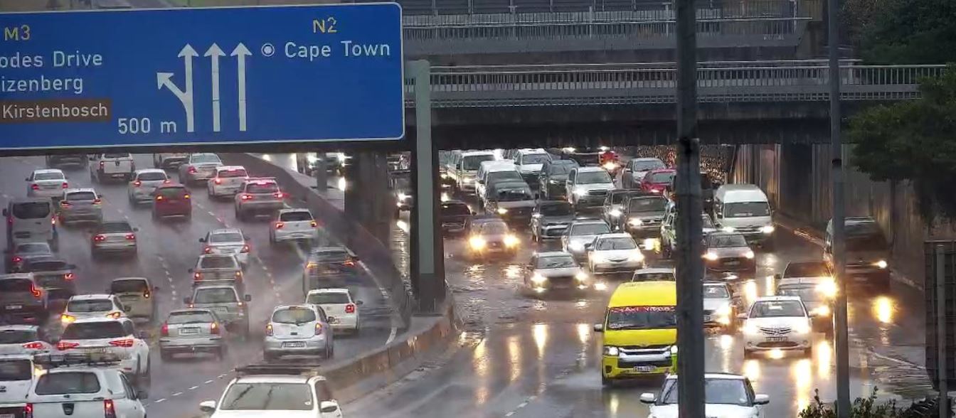
The City of Cape Town’s Traffic Services are currently responding to a surge in weather-related emergencies, following days of relentless rainfall that has inundated numerous key transport routes. Traffic congestion, submerged lanes, mudslides, and accidents have rendered many roads dangerous or impassable, prompting urgent safety appeals to the public.
“On the M3, a truck overturned at Upper Travato Link, resulting in multiple injuries and obstruction of the right lane,”
confirmed Maxine Bezuidenhout, spokesperson for Cape Town Traffic Services.
While that incident was being cleared, another vehicle breakdown intensified the pressure on traffic in the vicinity.
“Additionally, another truck broke down at Hospital Bend inbound on the M3, also blocking the right lane,”
she added.
⚠️ FLOOD UPDATE: Gentlemen’s estate in Val de Vie, Paarl has been flooded out by heavy rains and overflowing Berg River #CapeTown pic.twitter.com/zyBeYVgYys
— Ash Müller (@askashbroker) June 14, 2023
City Roads Become Rivers
As rainfall continued into the week, extensive flooding was reported along major highways and arterial routes. The right lane of the N2 outbound, between Mowbray Main Road and Liesbeek Parkway, was found to be submerged. Simultaneously, the Stellenbosch Arterial eastbound at Robert Sobukwe experienced flooding in the left lane, according to city officials.
In several suburbs, conditions have deteriorated dramatically. Roads have become treacherous rivers, and landslides have added to the hazards, leaving vehicles stranded and impeding emergency services. Authorities are discouraging any non-essential travel as a precautionary measure.
“We advise road users to be patient, allow extra travel time, and drive with headlights on at all times. Please maintain a safe following distance as these conditions are likely to impact traffic flow,”
Bezuidenhout cautioned.
Closures and High-Risk Areas
- Several road closures and areas of concern have emerged as rainfall overwhelmed drainage systems:
- Nelson Mandela Boulevard inbound, just after Newmarket Street, is completely submerged and currently hazardous to navigate.
- On the N1 inbound at Durban Road, the right lane is closed due to persistent water accumulation.
- Multiple segments along the N2 outbound have been flagged:
- Between Robert Sobukwe Road and Airport Approach Road
- At Liesbeek Parkway, where floodwater has obstructed the right lane
- Boys Drive towards Kalk Bay has partial flooding near a known speed camera site, closing the left lane.
- Baden Powell Drive remains one of the most severely impacted stretches:
- Between JK Masemola/Macassar Road and the N2 (eastbound)
- At Sunrise Boulevard, westbound toward Muizenberg
Motorists travelling in these areas are strongly advised to reduce their speed and be alert for hidden hazards, such as standing water and diminished visibility.
Traffic Bottlenecks in the South Peninsula
Flood alerts extend across the Southern Peninsula, further complicating mobility and delaying commutes.
On Ou Kaapse Weg, between the S-Bend and Steenberg Road in the direction of Tokai, motorists have encountered major delays. Kommetjie Road is heavily waterlogged, with limited visibility making conditions especially perilous.
Main Road, connecting Simon’s Town and Fish Hoek, has emerged as another crisis point. In Glencairn, vehicles are being forced to turn around due to impassable conditions. Nearby, both Harbour Bay Mall and the Kelp Factory vicinity have reported mudslides.
“The Simon’s Town train station and Glencairn Beach area are completely flooded,”
Bezuidenhout confirmed.
Flooding Crisis in the Cape Flats
In the Cape Flats, the situation remains dire. Prince George Drive, spanning from Nando’s in Grassy Park through to Lavender Hill, is overwhelmed with rising water levels, effectively paralyzing traffic movement and putting infrastructure under strain.
Flooding in some communities in Cape Town. pic.twitter.com/a8vyhIJJ4U
— Athi Mtongana (@AthiMtongana) July 1, 2021
Structural Failures Add to the Risk
In one of the more alarming developments, a retaining wall adjacent to a bridge over the N1 behind Tyger Valley collapsed. The wall gave way near the golf driving range, triggering a dangerous flow of water and mud across the roadway. Motorists have been advised to steer clear of this area entirely due to the instability of the terrain.
Ongoing Response and Public Appeal
City officials and emergency responders remain on high alert as weather conditions persist. While teams work to restore access and clear blocked routes, the City has reiterated that public safety remains the priority.
Authorities continue to monitor high-risk areas and encourage residents to report road hazards and comply with all traffic advisories. The impact of the flooding is expected to persist into the coming days, with concerns that further rainfall could exacerbate the situation.
In light of these developments, the message from Cape Town’s Traffic Services is clear: exercise extreme caution, stay informed, and limit travel unless absolutely necessary.